Blog
Review all articles from our blog.
Media Collection
Access digital collection of stories, articles, Op-eds, blogs, ethnographic photography, videos, interviews and data amplifying the Africa borderlands experiences and voices and contributing to ‘Leave No One Behind’
Portal Guidelines
Access and download a copy of the portal guidelines from this section.
Data
Access the Encyclopaedia data and other borderlands data resources
Agriculture
Strengthen agriculture and livestock production, productivity and enhance associated value and supply chains
Infrastructure
Invest in climate-resilient small infrastructure to enhance production and trade
Inclusion and Entrepreneurship
Provide access to finance and support the entrepreneurship of micro and small enterprises engaged in informal cross-border trade
Social Cohesion
Strengthen vertical and horizontal social cohesion
African Countries
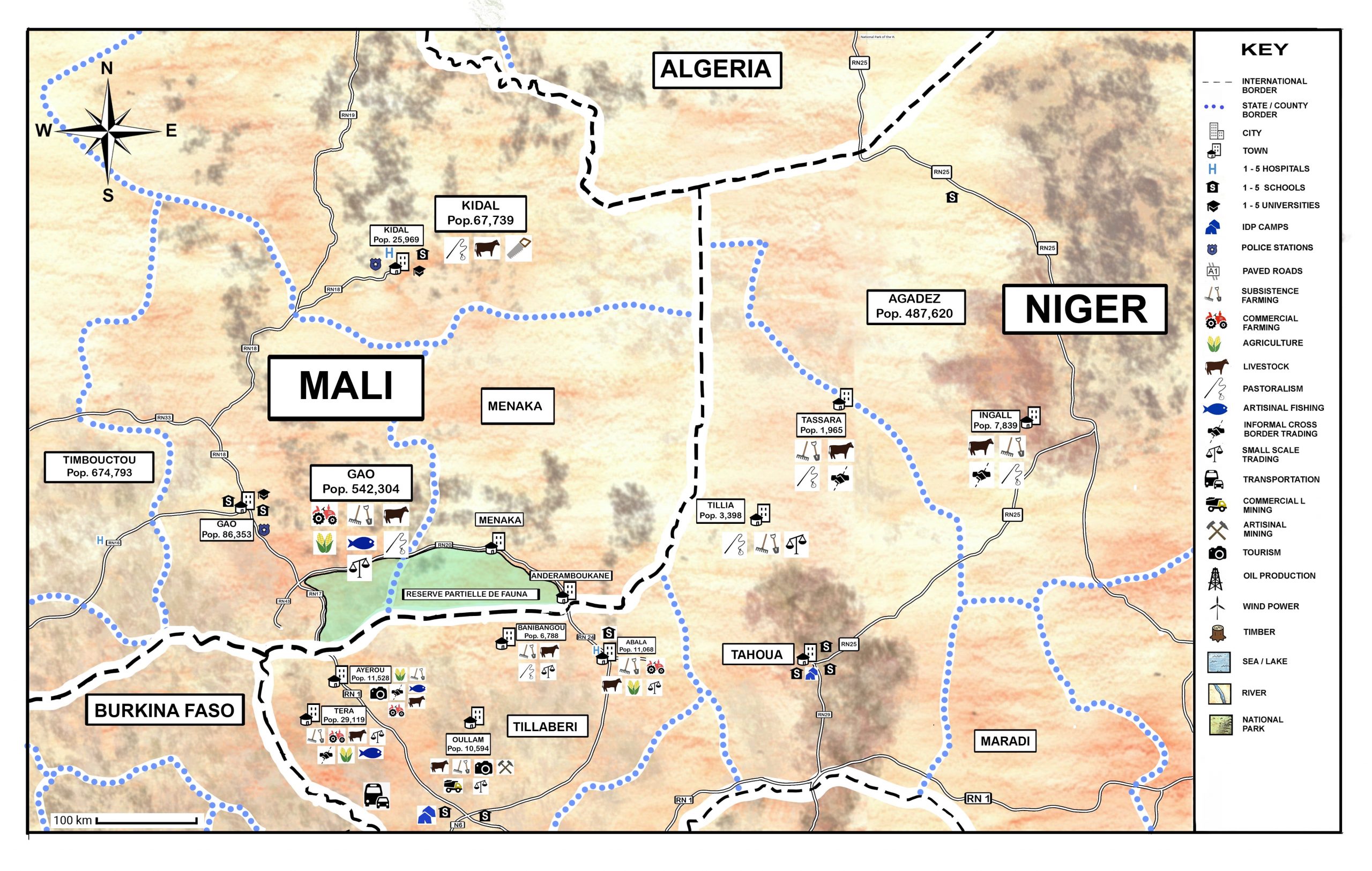
The Encyclopaedia covers a total of 106 terrestrial border pairs and trios spread across 54 African Union (AU) member states with an estimated 270 million borderlands people.
Borderlands Data
Access authoritative Africa borderlands socio-economic data using interactive charts, graphs and summary tables. Compare data across different border pairs and against national and international benchmarks and track progress in the advancement towards the SDGs.
About us
Africa's borderlands and their communities are a unique source of ingenuity, places of untapped opportunities and great resilience. In many of these regions, insecurity and poverty disguise the true socio-economic potential of borderlands and their communities. In improved circumstances, borderland communities could thrive by unlocking their potential and rich culture that will be critical to achieving Agenda 2030
FAQs
Frequently asked questions (faqs) for the encyclopedia of africa borderlands
Reviews
Do you have any issue with the data posted on this portal? Would you like to raise a review, comment or correction? Please use the form below to highlight what should be corrected and indicate the factual sources.
Disclaimer
The designations employed and the presentation of the information in this website do not imply the expression of any opinion whatsoever on the part of the United Nations Development Programme concerning the legal status of any country, territory, city or area or of its authorities, or concerning the delimitation of its frontiers or boundaries.
Contact us
UNDP Resilience Hub for Africa
United Nations Development Programme
UNON Complex Gigiri, Block M, Level 3,
P.O. Box 30218-00100
Nairobi, Kenya